fholbert
Mod's - Please don't edit my posts!
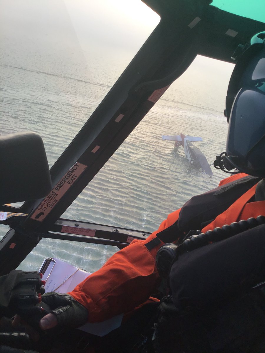
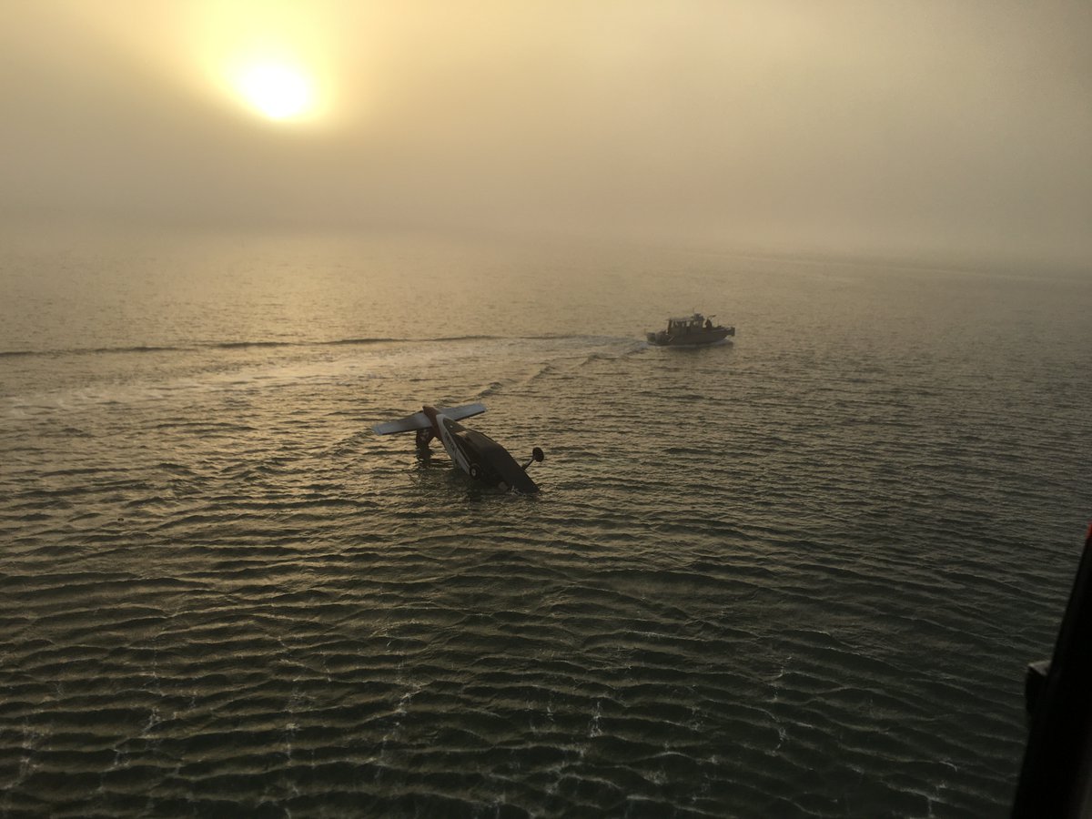
The aircraft impacted the waters of Arcata Bay during a landing attempt in fog conditions to Murray Field Airport, Eureka, California. The airplane came to rest inverted, sustaining substantial damage, and the sole pilot onboard was not injured.
Great pictures!!


EUREKA, Calif. — Coast Guard and partner agencies responded to a plane crash in North Humboldt Bay, Thursday morning.
At approximately 7:10 a.m., the Eureka Police Department relayed a distress call to Coast Guard Sector Humboldt Bay watchstanders from a commercial pilot after his plane crashed. Watchstanders dispatched a Coast Guard Station Humboldt Bay 29-foot Response Boat Small boatcrew, a Coast Guard Air Station Humboldt Bay MH-65 Dolphin helicopter crew and a small boatcrew from the Coast Guard Cutter Dorado to respond.
Watchstanders also issued an Urgent Marine Information Broadcast requesting assistance from mariners in the area and notifying them of the hazard to navigation.
At approximately 7:50 a.m., the Dolphin helicopter crew and a Humboldt Bay Port Authority small boat arrived on scene. The small boat recovered the pilot with no reports of any injuries.
"The environment in the Humboldt Bay area can be very unforgiving and dangerous to both boats and aircraft, which is why a strong network of maritime partners is so important," said Capt. Clint Schlegel, the Sector Humboldt Bay deputy commander. "We are extremely grateful to the Humboldt Bay Port Authority for rescuing the aircraft pilot. In cases like this, every second counts and their actions prevented this incident from taking a tragic turn."
The pilot was safely transferred to emergency medical services at Woodley Island Marina.
There are no reports of pollution at this time.
Great pictures!!
EUREKA, Calif. — Coast Guard and partner agencies responded to a plane crash in North Humboldt Bay, Thursday morning.
At approximately 7:10 a.m., the Eureka Police Department relayed a distress call to Coast Guard Sector Humboldt Bay watchstanders from a commercial pilot after his plane crashed. Watchstanders dispatched a Coast Guard Station Humboldt Bay 29-foot Response Boat Small boatcrew, a Coast Guard Air Station Humboldt Bay MH-65 Dolphin helicopter crew and a small boatcrew from the Coast Guard Cutter Dorado to respond.
Watchstanders also issued an Urgent Marine Information Broadcast requesting assistance from mariners in the area and notifying them of the hazard to navigation.
At approximately 7:50 a.m., the Dolphin helicopter crew and a Humboldt Bay Port Authority small boat arrived on scene. The small boat recovered the pilot with no reports of any injuries.
"The environment in the Humboldt Bay area can be very unforgiving and dangerous to both boats and aircraft, which is why a strong network of maritime partners is so important," said Capt. Clint Schlegel, the Sector Humboldt Bay deputy commander. "We are extremely grateful to the Humboldt Bay Port Authority for rescuing the aircraft pilot. In cases like this, every second counts and their actions prevented this incident from taking a tragic turn."
The pilot was safely transferred to emergency medical services at Woodley Island Marina.
There are no reports of pollution at this time.


") ) there. The Navy did all sorts of instrument flying work at ACV.
) there. The Navy did all sorts of instrument flying work at ACV.