C550 down in California French Valley Airport

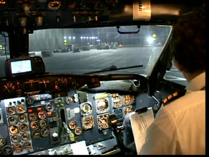
Looking at that cockpit photo, I’m wondering if they were using a handheld GPS or something on the glare shield to fly that approach???


Sent from my iPhone using Tapatalk

That is how Daallo Air of Somalia\Djibouti and many other carriers like African Express Airlines got down for decades before they got planes with good glass, with no accidents that I know of in that timeframe either. I think African Express Airlines still rocks DC-9s with the glaresheid GPS.
i.png


6588747215_56f683fa86_b.jpg
 
"Hey what's that mountain goat doing way up here?"
Pretty much. I was figuring botched go around. Never would have guessed they just flew it right into the ground. Now I'm really wondering as to what he thought he saw that told him he had the runway in sight.
 
Or cancelling IFR into an airport that was certainly in IMC. Unless he really didn’t check the weather.

I’m curious about fuel reserves which may have added to the pressure to make French valley.
 
Maybe had ground contact or the reils on the first try and thought if he could just get a few feet lower next time...

Or maybe he had nothing and decided "an LPV is basically an ILS I'll just make my decision a little slower"

Or maybe they were both too focused outside and no one noticed they went below mins.

Did anyone check out the flightaware track to see which mins they were using?
 
Last edited:
Did anyone check out the flightaware track to see which mins they were using?
I find ADSB Exchange more detailed but I'm unsure at how much more accurate.

According to that he went all the way to 1625 on the first approach. So it looks like LPV mins. The second approach right at 1600 feet the rate of descent increases dramatically. Could be error in the data though right at the end.
 
Interesting that they both only had commercial certs vs ATPs. Two thoughts, they must have been pretty low time to not have been issued ATPs on their type rides. And, secondly, I’m surprised that a 135 operator (I’m assuming they worked for a 135 outfit based on a previous post) can insure the PIC of a jet like this with such low time.
 
So exporting the adsb data and putting it in google earth tells a pretty good story.

Taking the data for what it's worth. you can see where he went missed on the first approach. If he was following the guidance the second was just a bit higher at the point where he hit the DA on the first try.
Vert.jpg


From a top down view the second approach shows just the slightest track deviation from the laser focused track of the first approach. My guess is the second on he started hand flying it a little ways back. That second red line I drew from the runway stops 650 feet from the approach end. 500 feet short puts him on the road. I cant find anything solid on whether he was inside the road to the runway or short of the road. In the pictures it sure doesn't look like they slid very far either.

above.jpg


rwy.jpg
 
With only REILs and MIRLs I'm surprised the mins on the field are under a mile. Wonder how much gas he took off with.
 
With only REILs and MIRLs I'm surprised the mins on the field are under a mile. Wonder how much gas he took off with.

That's what I'm thinking. We shoot ILS/LPVs to mins on steam gauges routinely around my neck of the woods. However - 1. We're familiar and experienced. 2. There is some kind of ALS. 3. There's no terrain to hit.

These attempts looks sketchy to me. Why not just land at riverside, chino, or any other airport nearby with good approaches and probably vfr conditions?
 
That is how Daallo Air of Somalia\Djibouti and many other carriers like African Express Airlines got down for decades before they got planes with good glass, with no accidents that I know of in that timeframe either. I think African Express Airlines still rocks DC-9s with the glaresheid GPS.
i.png


6588747215_56f683fa86_b.jpg

I've done it too in King airs and I flew CE-550 #74 another 1979 model almost the same as the accident aircraft. The problem is that using that type of GPS isn't legal for approaches.
 
That's what I'm thinking. We shoot ILS/LPVs to mins on steam gauges routinely around my neck of the woods. However - 1. We're familiar and experienced. 2. There is some kind of ALS. 3. There's no terrain to hit.

These attempts looks sketchy to me. Why not just land at riverside, chino, or any other airport nearby with good approaches and probably vfr conditions?

Thier cars were parked at French Valley and they'd have to repo the aircraft later once the fog burned off.
 
I didn't realize they were in Vegas for a grand total of 5 hours. Took off from FV at 9PM and were on their way back by 3AM. What was the point?
 
I've done it too in King airs and I flew CE-550 #74 another 1979 model almost the same as the accident aircraft. The problem is that using that type of GPS isn't legal for approaches.

It's that just a general observation, or are you speaking to the accident aircraft specifically?


There is a Garmin GTN750 in the middle of the panel, directly above the gear handle and left of the comm radios. It's a very capable, touchscreen, WAAS-enabled GPS Nav/Com unit. Very common retrofit on these old jets.
 
You dont know why people rich enough to charter a jet might go to vegas in the middle of the night for a few hours and then hop back home before day break?

lol it’s not even that bad of a trip. Compared to the abuse I put up with for 10 years. The only thing is I’d be getting yelled at by the lead PAX because I diverted and they’d have to take a limo I arranged to their cars.


Sent from my iPhone using Tapatalk
 
That's what I'm thinking. We shoot ILS/LPVs to mins on steam gauges routinely around my neck of the woods. However - 1. We're familiar and experienced. 2. There is some kind of ALS. 3. There's no terrain to hit.

These attempts looks sketchy to me. Why not just land at riverside, chino, or any other airport nearby with good approaches and probably vfr conditions?
It's not a bad airport at all, but it would be the last place I'd want to try to go with what the reported weather was.

Anyway, what a chamber of horrors.

 
Back
Top