Douglas
Old School KSUX
Any Florida CFIs around?
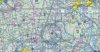
I have a friend in florida that is about to fly from the south to the north, VFR.
She stumped me.
There is a section of special use airspace that runs coast to coast, E to W. The airports the vicinity are St. Augustine, Gainsville Regional and Lake City (LCQ).
There are altitudes and frequencies available on the sectional.
I noticed the airspace black hash marks are at a 45 degree angle so I looked it up in part 93, but couldn't find any info on it. (wrong color I suppose for that)
What type of special use airspace is it?
Can you fly through it VFR? Without permission?
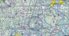