Thank You Steve !!!Mod note: political discussion on this accident is now here:
You are using an out of date browser. It may not display this or other websites correctly.
You should upgrade or use an alternative browser.
You should upgrade or use an alternative browser.
PSA CRJ-700 AA midair collision
- Thread starter swakid8
- Start date
FlyingAccountant
Well-Known Member
One of the PSA pilots' father was an Army UH60 driver that flew in and out of the DC area often including the Pentagon. What are the damn odds?
Burrito
Position And Hold My Beer
IIRC from my aviation studydays, TCAS wasn't implemented as a regulation/requirement until 1981 - PSA 182 was in 1978.
Air Florida 90 was four years later -- deicing standards weren't really heavily improved until afterward. Again, written in blood.
Quick edit-
I only mean the importance and training from the ramp side of the industry as deicers of holdover times, application, ... Really, and the elements of trust being put into the applications.
arkflyr
Well-Known Member
All good, sent it to you in a dmMy bad. I was reviewing and saw the pic and thought it was the same. send me the link and I will put it back
fixedAll good, sent it to you in a dm
But really is it that big of a deal to make the helicopters just stay the F out of a busy class B? It saves a few minutes?
I don't get it.
There are things helos have to do inside Class B just like airplanes have to. Have to share the airspace and keep heads up.
BEEF SUPREME
Well-Known Member
There are things helos have to do inside Class B just like airplanes have to. Have to share the airspace and keep heads up.
At what cost?
Old Boeing Driver
Well-Known Member
Roger Roger
I am le tired
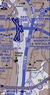
On the animations, they start off following the East bank but immediately before the collision deviate right into the middle of the river, for what reason we don’t know. A lot of speculation that they visually ID’d the wrong aircraft.I haven't read the entire thread, but it appears that on Helicopter Route 4, the Helo should have been on the eastern shore of the Potomac. Not closer to the approach end of 33.
Murdoughnut
Well sized member
NY Times is citing an internal FAA report saying the controller in question was "doing a job normally done by two people."
Roger Roger
I am le tired
Doesn’t really matter. If the Blackhawk calls traffic in sight, unless some other evidence comes up, this seems to be on them.NY Times is citing an internal FAA report saying the controller in question was "doing a job normally done by two people."
Kingairer
'Tiger Team' Member
Even if they were exactly at 200 and over the edge of the shore it would have been extremely close. I just measured and its about 3000 feet from the end of the runway to the edge of the shore. At 3000 thats a little more than the length of a typical MALSR approach lighting system. No way anyone was intending for a CRJ to pass overhead a 100 or so feet over the top of a blackhawk. If that was the intent they really miscalculated. I am in the camp of visually IDd the wrong aircraft (Imagine if one pilot says "got em and pointed to his right or in the distance how easy would it be for the other pilot to not even look in the other direction), or misjudged closure rate and direction.I haven't read the entire thread, but it appears that on Helicopter Route 4, the Helo should have been on the eastern shore of the Potomac. Not closer to the approach end of 33.
Murdoughnut
Well sized member
Doesn’t really matter. If the Blackhawk calls traffic in sight, unless some other evidence comes up, this seems to be on them.
Absolutely, and maybe this is better suited for the discussion on the other thread, but if this investigation can both show that ATC wasn't to blame, but that ATC resource shortages were a contributing factor, I think that's the best outcome we could get.
Kingairer
'Tiger Team' Member
Likely one of those holes. I know ATCers have been sounding that alarm alot lately.NY Times is citing an internal FAA report saying the controller in question was "doing a job normally done by two people."
Roger Roger
I am le tired
And if the FAA were an actual safety agency, they would have been throttling traffic to what their staffing would handle. But that would make it hard for airlines to hit their profitability targets so…Likely one of those holes. I know ATCers have been sounding that alarm alot lately.
Autothrust Blue
“If you jump on my shift, that’s just rude, man.”
There was a lot of 'immediate' in that recording, which has always struck me as a sign that things are, how you say, down the •ter at that position.And if the FAA were an actual safety agency, they would have been throttling traffic to what their staffing would handle. But that would make it hard for airlines to hit their profitability targets so…
NovemberEcho
Dergs favorite member
My guess is DCA tower has a dedicated class B advisory position like EWR/LGA/JFK have to talk to VFR’s in the corridors. It was combined up with local in this case because there wasn’t enough river traffic and/or staffing to justify opening it.NY Times is citing an internal FAA report saying the controller in question was "doing a job normally done by two people."
At what cost?
Getting patients to/from hospitals, patrol work, transport work, etc. Helos and fixed wing have coexisted for a very long time in Class B. Accidents like this are very rare events, and I’m sure this one will come with some operational changes on routes and altitudes in certain segments of routes, in the DCA area.
Roger Roger
I am le tired
Agree, a blanket ban is excessive, but I think that in retrospect we’ll look at certain routes and procedures as having been an accident waiting to happen. One also has to wonder, given that this was from a VIP unit, what the cost/benefit is of many of these helo missions. Similar to low-acuity HEMS transfers. Maybe a good thing for DOGE to look at…Getting patients to/from hospitals, patrol work, transport work, etc. Helos and fixed wing have coexisted for a very long time in Class B. Accidents like this are very rare events, and I’m sure this one will come with some operational changes on routes and altitudes in certain segments of routes, in the DCA area.