You are using an out of date browser. It may not display this or other websites correctly.
You should upgrade or use an alternative browser.
You should upgrade or use an alternative browser.
Corona Airport (KAJO) Going Under Water Again?
- Thread starter fholbert
- Start date
Pilotforhire587
Lycra Man
Sorry to hear that guys... Maybe Lake Mead will fill back up :/ If only...
z987k
Well-Known Member
Yeah, wtf SoCal. I get in and it's 75 and beautiful and the next day rain sets in for weeks and we can't get anything done.
On another note, all this rain has been snow in the Sierra's. Look at what Mammoth has received in the past few days. Last I saw was 15ft in 48 hours.
On another note, all this rain has been snow in the Sierra's. Look at what Mammoth has received in the past few days. Last I saw was 15ft in 48 hours.
RICHARD5
Well-Known Member
As you may know, the waters for Mead come out of UT/CO snowmelt. It's been a very good year for snow in the Rockies. However, as far as the lake filling up, the obligations to release water downstream will likely act against that. Especially since USA just re-ratified the water agreements with Mexico for the Colorado River.... Maybe Lake Mead will fill back up...
z987k
Well-Known Member
As you may know, the waters for Mead come out of UT/CO snowmelt. It's been a very good year for snow in the Rockies. However, as far as the lake filling up, the obligations to release water downstream will likely act against that. Especially since USA just re-ratified the water agreements with Mexico for the Colorado River.
IIRC, Mexico could basically empty lake mead with how much Vegas and other cities have been raping it, and what mexico is guaranteed by the treaty, if they wanted to.
Basically from what I understand, Vegas water usage + Mexico's allotment = dry Colorado river.
RICHARD5
Well-Known Member
IIRC, Mexico could basically empty lake mead with how much Vegas and other cities have been raping it, and what mexico is guaranteed by the treaty, if they wanted to.
Basically from what I understand, Vegas water usage + Mexico's allotment = dry Colorado river.
Actually, I was surprised to read of the treaty between the two countries. As long as I remember, the Colorado River has been dry or reduced to an underground trickle by the time it reaches the border. Mexico is entitled to 1.5 million acre feet per the treaty.
In the west, water is for fighting, whiskey for drinking.
Not after the lasr few days. It's been 5 days straight of rain. I think we got almost 10 inches out of the last series of storms.
Edit: Total is only 6.3". But some areas got as much as 12 inches.
I'm in Victorville so I know. Boy, it's been bad all over. Stay safe and warm and dry.
Weren't you on the complete opposite side of the country a few weeks ago?
A Life Aloft
Well-Known Member
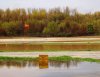
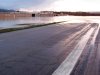
Almost needed a canoe today

fholbert
Mod's - Please don't edit my posts!
Almost needed a canoe today
Almost??? I took these pictures at Corona on Wednesday.

Attachments


swisspilot
Well-Known Member
Why does is flood so bad there? Is it in a mrsh or something? I can't tell much from the sat images.
I think the water can`t drain fast enough, in Florida many airport have huge ditches on the sides of runways and taxiways, when it rains a lot they fill up and usually it takes several days to be empty again, I can image that if there would be no ditches the airport will be underwater, LA has also a lot of asphalt that does not help with Drainage.
I think the water can`t drain fast enough, in Florida many airport have huge ditches on the sides of runways and taxiways, when it rains a lot they fill up and usually it takes several days to be empty again, I can image that if there would be no ditches the airport will be underwater, LA has also a lot of asphalt that does not help with Drainage.
We have a lot of asphalt, but the hilly terrian helps with dried up riverbeds, so it usually drains quite fast.
RICHARD5
Well-Known Member
Weren't you on the complete opposite side of the country a few weeks ago?
Yep but it was more than a few weeks ago that I returned from a one month stay on Cape Cod.
RICHARD5
Well-Known Member
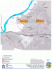
AJO lies within the Western Riverside County Multiple Species Wildlife Habitat. The Santa Ana River is a significant feature of that habitat and is immediately adjacent to the airport. There are restrictions on what the airport owner (City of Corona) can do to protect the airport from flooding.
EDIT: Correction: The US Army Corps of Engineers owns the airport. The city leases the airport. That the Corps owns the property should be a heads up about what is going on there.
Also, that "forest" immediately adjacent and to the north/northwest of the airport is part of the wildlife habitat. Besides causing mechanical turbulence for a sporty arrival into AJO, the trees, et al act as a buffer to allow the river to flood across hundreds of acres outside the river channel proper. The problem is when that water flows to the south (downstream) from that area. All the waters must again enter the river channel. The airport lies in close proximity to that point. Viola!--flooded airport at the west end.
Attachments
A Life Aloft
Well-Known Member
I heard today that the Bellanca owned by someone out there, is underwater and toast now. Is this true? Isn't that what you fly??? I am getting this info second hand so it may be incorrect. There can't be two of them there. Also heard that another guy who builds, designs (not sure the details of exactly what he does- I am sure you will know Frank - getting all this second hand from some guys at LGB today) lost all of his machinery/equipment. Many owners are saying that they got no warning notice from the management (management claimed to have sent one out three days prior) and one guy lost three helicopters. I think I'd be looking for another facility. Feel really badly for all the pilots who lost their aircraft or incurred severe damage. You were wise to beat feet outta there when you did. I saw some news photos and it's worse today, the water is still rising and we are due for another storm Sunday. Just a sad mess out there.