GPS Approach

juxtapilot

Snowflake
Use this airport (KRHP)

KRHP.jpg


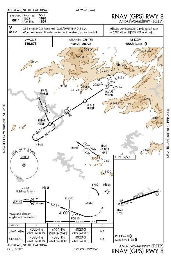
You fly to RHP and decend to Mins, you have the airport in sight, so you decend below mins to land, and before you are able to land you lose sight of the runway. By this time you are 2000 feet below minimums. What should you do as far as the missed approach procedure is concerned? Do you turn towards the runway and follow the missed approach?
 
So what your saying is that your doing a visual approach and lose sight right? It really depends on where you are on the plate. If your 2000 below mins, your only 300agl. Depending on where you are again, if it was me, I would start a climb back up to the MDA before I get to the MAP. Then, just follow the missed proc.
 
I would say:
Before MAP, fly to the MAP and then go missed, if after the MAP then follow missed. If you are 2k below mins you better be past the MAP anyway because you are only 300 or so above the airport.
 
I've worded this poorly. Lets say you are 2300ft MSL, 2 miles prior to the runway. You lose sight of the runway. How do you execute the missed? Climb while circling the airport?
 
At 2 miles from the airport, you're still 1.5 outside the MAP. Start your climb while tracking the FAC, then on reaching the MAP continue with the published missed. I think someone already said essentially this, but oh well.
 
At 2 miles from the airport, you're still 1.5 outside the MAP. Start your climb while tracking the FAC, then on reaching the MAP continue with the published missed. I think someone already said essentially this, but oh well.

Okay, so you cross the MAP at 3000ft during your climb. To fly the missed approach and still have obstacle clearance don't you have to cross the MAP at or above the minimum altitude (4020)? So if you cross the MAP BELOW that altitude by say 1000ft, you just fly the Missed approach procedure? If you go missed you may hit a mountain right?
 
If you get into that kind of a position you are in a world of hurt. There is no rule that will be right for every situation. You will need to decide for yourself the *safest* way for you to get yourself back into protected airspace. It may very well be that the best thing to do is to climb in a hold at the MAP until you get back up to minimums, but in other situations doing so might kill you. There is a reason that the rules say you can't descend until you can maintain visual all the way to the runway - because the TERPS guys can't protect you 100% below that altitude.

Now, if you want an opinion on this specific case, then I'd kind of like to know what aircraft I'm flying, and a little more information on what has caused me to lose sight of the airport. :)
 
Now, if you want an opinion on this specific case, then I'd kind of like to know what aircraft I'm flying, and a little more information on what has caused me to lose sight of the airport. :)
:yeahthat:
 
It's not completely unique. There's some other mountain airports with very similar situations. Check out Telluride for example:

http://www.airnav.com/depart?http://204.108.4.16/d-tpp/0901/06920G9.PDF

In your proposed scenario, I suppose I'd be doing some quick figuring on whether or not I think I'll break out of whatever I've just stumbled into and will see the field in the next 10 seconds or not. If it's fairly thick then I'm climbing as fast as I can, cleaning up the gear and getting flaps to the appropriate setting for the Missed. At the MAP I'd start a turn and if I'm not yet back up to 4,000 feet I'm about as puckered up as I can be. From the looks of the chart if I survive a 180 degree turn then I've probably missed everything that I'm going to miss and there really isn't a good reason to continue climbing over the MAP so I'm heading for HISEN. If I was going to hit a hill it would have been in the first 90 degrees to 180 degrees of turn.

Best plan is not to go below minimums unless I'm SURE I can keep the field in sight. :)
 
That's a hairy approach with all those 500-700ft towers all around the airport and all that terrain.

So don't get into that situation, lol. If you did - I'd say make a climbing turn back toward the airport and hold/climb over the MAP until at 4020 then fly the missed - when you report going missed let ATC know the situation. Looking at the missed, it looks like that would take you very close to those towers, and if you're very low, you're likely to smack them.

Also use your GPS terrain map, it's all you have to let you know the approximate location of the terrain/towers.

I wouldn't continue the approach if once I broke out at the MDA, I saw another layer(s) below me that might obscure the runway at some point during my approach. I'd imagine parts/tops of the mountains would still be visible though. I just don't see how you'd get so low and then lose sight of it. You'd be in very big trouble if somehow you got to 300 AGL and then a giant cloud descended on everything.

I'm taking my checkride Sunday, so I obviously don't have any real world IFR experience - hope I don't sound like a dumbass, LOL.
 
It's a unique situation with a very high MDA.

One option in your scenario is to be familiar with any obstacle DP's; they assume you're starting at airport elevation, rather than merely below MDA, so if it works for departure, it would likely work for you.
 
When in doubt, look to tgrayson.

Follow the published missed, you can't go wrong.
 
One option in your scenario is to be familiar with any obstacle DP's; they assume you're starting at airport elevation, rather than merely below MDA, so if it works for departure, it would likely work for you.
:yeahthat:
Although in this case, you're SOL.
"ANDREWS-MURPHY
TAKE-OFF MINIMUMS: Rwys 8, 26, max. 180 KIAS
3400-2, max. 210 KIAS 3400-2½, max. 250 KIAS 3400-3.
DEPARTURE PROCEDURE: Rwys 8, 26, procedure
NA at night. Remain within 3 NM of Andrews-Murphy
Airport while climbing in visual conditions to cross
airport westbound at or above 4900. Then climb to 7000
via heading 251° and HARRIS (HRS) VORTAC R-356
to HRS VORTAC before proceeding on course."
In some cases there are ODPs that you can follow. This is not uncommon out west where going missed below DA/DH may put you into granite maximus if you follow the MAP.
 
When in doubt, look to tgrayson.

Follow the published missed, you can't go wrong.

In this case, though, you could go wrong because you're so far below (1700') the MDA. If you can get up to the MDA by the MAP, you'd get the protection the TERPS provide. If not, you risk not having the required terrain clearance.

Making a left turn as described in the MAP from 600' AGL might be really sketchy. The terrain there is really close on the NW side of the airport. My airline flies into a couple mountain airports with very high MDA's, and at one (ASE) they've developed an "emergency extraction procedure" in case runway contact is lost after the MAP. I know one guy who had to do it. It was apparently not fun at all.
 
:yeahthat:
Although in this case, you're SOL.
"ANDREWS-MURPHY
TAKE-OFF MINIMUMS: Rwys 8, 26, max. 180 KIAS
3400-2, max. 210 KIAS 3400-2½, max. 250 KIAS 3400-3.
DEPARTURE PROCEDURE: Rwys 8, 26, procedure
NA at night. Remain within 3 NM of Andrews-Murphy
Airport while climbing in visual conditions to cross
airport westbound at or above 4900. Then climb to 7000
via heading 251° and HARRIS (HRS) VORTAC R-356
to HRS VORTAC before proceeding on course."
In some cases there are ODPs that you can follow. This is not uncommon out west where going missed below DA/DH may put you into granite maximus if you follow the MAP.

In this case, though, you could go wrong because you're so far below (1700') the MDA. If you can get up to the MDA by the MAP, you'd get the protection the TERPS provide. If not, you risk not having the required terrain clearance.

Making a left turn as described in the MAP from 600' AGL might be really sketchy. The terrain there is really close on the NW side of the airport. My airline flies into a couple mountain airports with very high MDA's, and at one (ASE) they've developed an "emergency extraction procedure" in case runway contact is lost after the MAP. I know one guy who had to do it. It was apparently not fun at all.

This is kind of what I was looking for. I didn't think TERPS would give you clearance below the MAP altitude.

Thx for the comments guys.
 
If you lose sight of the airport below mins you have two choices.

1) Go missed.
2) Undo what you just did.

Option one isn't that easy however, as you might not be able to maintain obstacle clearance and you might hit something.

Option two isn't always easy either however, as the only way you can undo what you just did is do a climbing turn away from the nearest terrain in an attempt to break out. This is dubious because you might hit something else.

The only way you can know what to do is be intimately familiar with the terrain every time you go in their.

From the view of the sectional below, I see a road and a railroad, if you lose sight of airport around that point somewhere, and your are straight up IMC the first thing you should be looking for as you turn around is the road and railroad. For your turn around, I'd recommend a right turn.

If that's not possible to turn (you're wayyyy too heavy, its way too hot or the winds prohibit it safely), and if you have an MFD or a GPS with some mountain info in it, you might conisder continuing on rather than trying to turn into mountains that low. Throw the whips to it and follow the pass until you hit 5900' or so, and you'll be clear of all the obstacles in that sector. That however, is the last resort only.

Another possibility is combine avionics, and go direct to the NDB while maintaining obstacle clearance with the GPS, that's probably what I would do if I was really SOL below mins, and had no real good options.

It really depends on what you're flying though.
 

Attachments

  • Picture 4.jpg
    Picture 4.jpg
    127.6 KB · Views: 81
Just a hypothetical question. There was just some questions about this. It's a unique situation with a very high MDA.

I was thinking it'd be in a PA44 or something of that sort...
in 1.5nm i am going to climb more than 700ft in a PA44. in the summer time mabye 1200ft or so, in the winter more like 2000ft

and why did I lose sight of the runway?
 
Back
Top