You are using an out of date browser. It may not display this or other websites correctly.
You should upgrade or use an alternative browser.
You should upgrade or use an alternative browser.
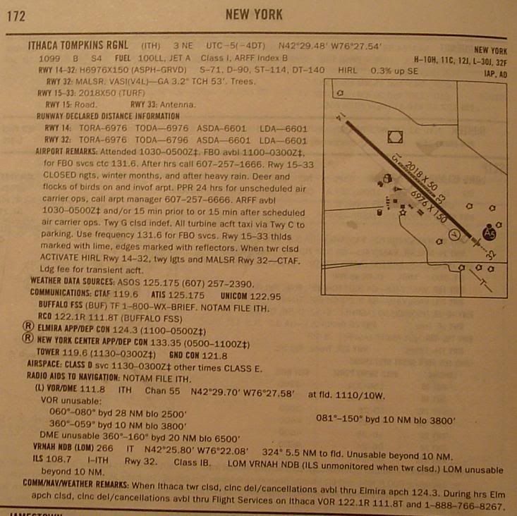
TPA question.
- Thread starter Holocene
- Start date
SpiceWeasel
Tre Kronor
I used to get the AOPA airport directory, which always listed pattern altitudes. Strangely enough, I don't see that information listed in the A/FD...
I mean, typically all you have to do is add 1000' to field elevation, but sometimes it can be less.
Uh.... it is in the A/FD. I pulled this excerpt off of the Digital A/FD onine.
http://www.avn.faa.gov/afd.asp?cycle=afd_15JAN2009&eff=01-15-2009&end=03-12-2009#results
Reid-Hillview lists it as 1135 MSL
San Luis County Regional has 3: 1212 MSL, 1203 MSL, and 1703 MSL.
To aid you in locating it on the A/FD, I've highlighted it in red with Bold/Italic/Underline
REID–HILLVIEW OF SANTA CLARA CO
(RHV) 4 SE UTC8(7DT) SAN FRANCISCO
N37
°19.97W121°49.19L–2F, 3B
135 B S4
FUEL 100LL, JET A OX 2, 4 TPA—1135(1000) IAP, AD
RWY 13L–31R:
H3100X75 (ASPH) S–17 MIRL 0.4% up NW
RWY 13L:
REIL. VASI(V2L)—GA 4.0° TCH 25. Thld dsplcd 499.
Tree.
RWY 31R:
REIL. VASI(V2L)—GA 4.0° TCH 17. Thld dsplcd 410.
Road. Rgt tfc.
RWY 13R–31L:
H3099X75 (ASPH) S–17 0.4% up NW
RWY 13R:
Thld dsplcd 499. Tree. Rgt tfc.
RWY 31L:
VASI(V2L)—GA 4.0° TCH 17. Thld dsplcd 409. Road.
AIRPORT REMARKS:
Attended 1500–0600Z‡. Self–fueling avbl 24/7.
Birds on and invof arpt. Rwy 31R calm wind rwy when twr closed.
No pure jet or surplus military acft except those meeting FAR 36
noise criteria. No touch and go landings 0500–1500Z
‡. No
simulated emergencies in arpt tfc area. No turns blo 500
when
leaving pattern except Rwy 31R departures—as soon as
practicable after departure make a slight right turn to avoid school
one half mile off departure end. When twr clsd ACTIVATE MIRL Rwy
13L–31R, REIL Rwy 13L and Rwy 31R—CTAF. VASI Rwy 13L, Rwy
31R and Rwy 31L opr continuously.
WEATHER DATA SOURCES:
LAWRS.
COMMUNICATIONS: CTAF
119.8 ATIS 125.2 (408) 923–7100
UNICOM
122.95
OAKLAND FSS
(OAK) TF 1–800–WX–BRIEF. NOTAM FILE RHV.
R NORCAL APP CON 120.1 134.5 133.95
R NORCAL DEP CON 121.3
REID–HILLVIEW TOWER
119.8 (Rwy 13L–31R) 126.1 (Rwy 13R–31L) (1500–0600Z‡) GND CON 121.65
AIRSPACE: CLASS D
svc 1500–0600Z‡ other times CLASS G.
RADIO AIDS TO NAVIGATION:
NOTAM FILE SJC.
SAN JOSE (L) VOR/DME
114.1 SJC Chan 88 N37°22.48W121°56.68097° 6.5 NM to fld. 43/16E.
COMM/NAV/WEATHER REMARKS:
Emerg frequency 121.5 not avbl at tower.
SAN LUIS OBISPO
SAN LUIS COUNTY RGNL
(SBP) 3 S UTC8(7DT) LOS ANGELES
N35
°14.24W120°38.56H–4G, L–3D, 7A
212 B S4
FUEL 100LL, JET A OX 1, 3, 4 TPA—See Remarks Class I, ARFF Index A IAP, AD
RWY 11–29:
H6100X150 (ASPH–GRVD) S–50, D–65, ST–82
HIRL 0.8% up SE
RWY 11:
MALSR. VASI(V4L)—GA 3.0° TCH 50. Thld dsplcd 800.
RWY 29:
REIL. VASI(V4L)—GA 3.25° TCH 50. Thld dsplcd 500
RWY 07–25:
H2500X100 (ASPH) S–12.5, D–12.5 1.1% up E
RWY 07:
Road.
ARRESTING GEAR/SYSTEM
RWY 11:
EMAS 300X 170
RWY 29:
EMAS 312X 170
AIRPORT REMARKS:
Attended 1400–0100Z‡. Recurring flocks of
waterfowl on and in vicinity of arpt during winter months. Twr
unable to see acft in holding bay at NW end of Twy A. Movement
from holding bay rqrs tower approval during twr hrs. Noise
sensitive arpt. For noise abatement information ctc arpt manager
805–781–5205. Rwy 29 designated calm wind rwy.
TPA—1212(1000). TPA—1203 (991) single engine; 1703 (1491)
multi–engine, jet and high performance. Taxilane widths less than
standard. When twr clsd ACTIVATE MALSR—CTAF.
WEATHER DATA SOURCES:
ASOS (805) 547–1260. LAWRS.
COMMUNICATIONS: CTAF
124.0 ATIS 120.6 UNICOM 122.95
HAWTHORNE FSS
(HHR) TF 1–800–WX–BRIEF. NOTAM FILE SBP.
R SANTA BARBARA APP/DEP CON 127.725 (1400–0700Z‡)
R L.A. CENTER APP/DEP CON 119.05 (0700–1400Z‡)
TOWER
124.0 (1400–0400Z‡) GND CON 121.6
AIRSPACE: CLASS D
svc (1400–0400Z‡) other times CLASS G.
RADIO AIDS TO NAVIGATION:
NOTAM FILE HHR.
MORRO BAY (L) VORTACW 112.4 MQO Chan 71 N35°15.14W120°45.57083° 5.8 NM
Holocene
Well-Known Member
Uh.... it is in the A/FD. I pulled this excerpt off of the Digital A/FD onine.
Thanks for the help man, but I'm telling you, it's not listed in my paper version.

Noted. If not listed, the good rule of thumb is as you originally wrote...add 1000' to the field elevation. Generally, that holds true for light civil aircraft, with heavier aircraft and jets being at 1500', and helos at 500' or lower. That'll work unless you have a designated TPA your aircraft needs, such as the F-117, where we used 2000' TPA and requested such at other fields if there was no conflict. TPAs can extend up to 3000 AGL.
meritflyer
Well-Known Member
You would fly 1000' AGL.
AC 90-66A:
AC 90-66A:
AC 90-66A said:It is recommended that airplanes observe a 1000 foot above ground level (AGL) traffic pattern altitude. Large and turbine powered airplanes should enter the traffic pattern at an altitude of 1,500 feet AGL or 500 feet above the established pattern altitude. A pilot may vary the size of the traffic pattern depending on the aircraft's performance characteristics.
RICHARD5
Well-Known Member
That's interesting you'd pull up KSBP. That's my home of 30+ yrs. Boy howdy, do I miss it.
Yeah, sometimes TPA is not shown. Then it's 800 or 1,000. I plan on 1,000 agl unless it is shown as otherwise.
WHY it's not shown is something I half remember from the distant past. meaning...right now I don't have the answer.
Yeah, sometimes TPA is not shown. Then it's 800 or 1,000. I plan on 1,000 agl unless it is shown as otherwise.
WHY it's not shown is something I half remember from the distant past. meaning...right now I don't have the answer.
