TXTBOOK
Well-Known Member
Hey, quick question.
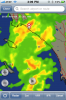
I just got the Foreflight App on my iPhone, and I've been tracking the storm that's over Southern California today.
What do the numbers within the cells mean, and what does that little icon with two arrows going around in a circle mean?
I'm guessing these are winds-aloft figures at specific points in the storm, and maybe the icon is an indication of swirling winds? Potential for a tornado? :dunno:
Attached is the screenshot with what I am talking about.
Thanks for the help :beer: