meritflyer
Well-Known Member
For you guys using FMS, I read that that DME is measured in slant range. So naturally, does the slant range errors affect even airplanes that have advanced avionics (DME).?
Huh.. interesting. Does the DME in a RJ work the same in any other airplane? If it does, I'd think that slant range error would be a definate possibility.
Not every FMS has a GPS attached to it. Several RJs have FMS but no GPS. However that works out..
At Mesa, there are plenty without GPS from what I hear.
I haven't flown one that doesn't have one. If the GPS is not functioning, that is a different story.
How so? Just because there isn't a GPS input being made into the FMS doesn't mean it can't determine it's lat/long by another means. Hence, no slant range error unless you are in green needles.
Computation of Position
Each FMGC computes its own aircraft position (called the "FM position") from a MIX IRS position, and a computed radio position or a GPS position.
The FMGS selects the most accurate position considering the estimated accuracy and integrity of each positioning equipment.
GPS/INERTIAL: is the basic navigation mode provided. GPS data are valid and successfully tested. Otherwise NAVAIDS plus inertial only are used.
FM Position
At flight initialization, each FMGC displays an FM position that is mix IRS/GPS position (GPIRS). It is subsequently updated:
- At takeoff, when the FM position is updated to the runway threshols position as stored in the database, possibly corrected by the takeoff shift entered in the [takeoff performance page].
- In flight, the FM position approaches the radio position or the GPS position at a rate depending upon the aircraft altitude.
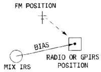
Bias
Each FMGC computs a vector from its MIX IRS position to the radio or GPIRS position. This vector is called the "bias."
Each FMGC updates its bias continuously as a radio position or a GPIRS position is available.
If an FMGC looses its radio/GPIRS position, it memorizez the bias and uses it to compute the FM position, which equals the mix IRS position plus the bias.
Until the radio or the GPIRS position is restored, the bias does not change.
The crew can update the FM position manually. This also updates the bias.
MIX IRS Position
Each FMGC receives a position from each of the three IRSs and computes a mean ewighted average callled the "MIX IRS" position. If one of the IRSs fails, each FMGC uses only one IRS (onside or IRS3). Each IRS position and velocity is continuously tested. Is the test fails, the corresponding IRS is rejected.
When the MIX IRS position differs from the radio position by more than 12 NM [a light comes on and an angel gets its wings].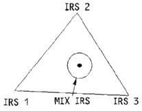
GPS Position
duh...
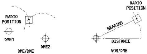
Radio Position
Each FMGC uses onside navaids to compute its own radio position. ...The navaids it can use are:[The FMGC] uses LOC to update the lateral position using LOC beam during an ILS approach.
- DME/DME
- VOR/DME
- LOC
- DME/DME-LOC
- VOR/DME-LOC
LOC is also used for quick updates when in GPS/IRS mode (if GPS installed).
If one or more navaids fail, each FMGC can use its offside navaids to compute a VOR/DME or DME/DME radio position.
") . If you're looking for something to do, read up on exemption 3585.
. If you're looking for something to do, read up on exemption 3585.