Controlled Crash Landing In Utah

No it is not

It is too early to put the blame on the pilot without the NTSB's findings as aloft did. It could be his fault or it could not be as far as we are all concerned right now. We shall find out soon enough from the NTSB.
 
It is too early to put the blame on the pilot without the NTSB's findings as aloft did. It could be his fault or it could not be as far as we are all concerned right now. We shall find out soon enough from the NTSB.
Did you actually read the article?

James Johnson Archive “He told them that they were flying in a canyon by the Green River Channel,” said Adams. “He said the weight of the gear they were carrying and changing conditions in the canyon made it difficult for them to regain altitude. John Bridewell decided to perform a controlled crash landing in terrain level to the river
desolation.jpg

The aptly named Desolation Canyon has an elevation differential from the bottom to the surrounding peaks of roughly 3-4000 feet or more in a few areas. As I said already, it has been above 100 degrees in that area for weeks. Assuming that the temp was 100 degrees the Density altitude at the BOTTOM of the canyon would be about 8500 feet.

You can make all the excuses you want for this guy, but in July you just don't get into these canyons in the first place. It is just plain stupid.
 
PS: last July's Density Altitude Champion
l_673000126ed21538c0bf379d91e3bdfc.jpg


Shockingly all four survived. I flew this plane the day before it crashed.
NTSB Identification: LAX07CA213.
The docket is stored in the Docket Management System (DMS). Please contact Records Management Division
14 CFR Part 91: General Aviation
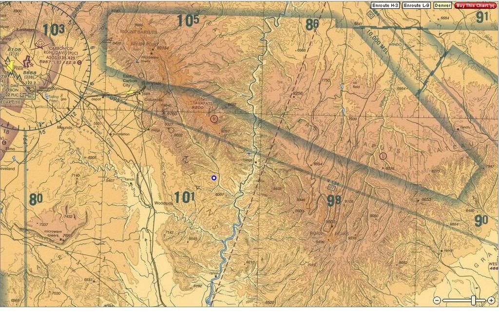
Accident occurred Monday, July 09, 2007 in Strawberry Rese, UT
Probable Cause Approval Date: 8/30/2007
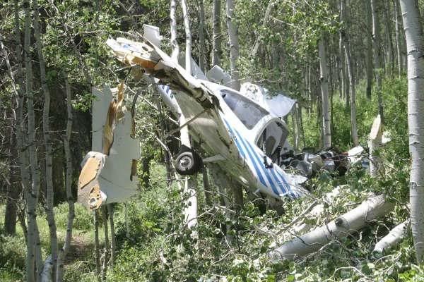
Aircraft: Diamond Aircraft DA40-G1000, registration: N747PZ
Injuries: 2 Minor, 2 Uninjured.The airplane impacted rising mountainous terrain while flying in a box canyon. The pilot was flying at 7,500 feet msl in mountainous terrain that varied from 7,000 to 9,000 feet msl. His passenger spotted an elk and he maneuvered the airplane into a slight left turn in an attempt to view the elk. The maneuver put the airplane into the entrance of a draw. Within seconds the draw started to rapidly converge. The pilot applied full power and stared to climb but it was clear that the airplane was not going to clear the terrain. He also determined that a 180-degree turn out of the draw was not possible. He continued to fly the plane straight ahead and bled off as much air speed as possible before colliding with the trees. The airplane impacted the trees, turned 90 degrees, and was captured by the trees in a nose down attitude. The pilot and three passengers were able to egress the airplane with out difficulty. The pilot stated that the airplane and engine had no mechanical failures or malfunctions during the flight.


The National Transportation Safety Board determines the probable cause(s) of this accident as follows:
The pilot failed to maintain adequate terrain clearance. Contributing to the accident was the pilot's decision to turn into upsloping terrain at a low altitude.
Did both of these accidents occur on July 9th?
 
Haha don't say that bro, dont jynx it....Though its VFR I bet in your pic you diddnt even know your flying upside down......and you were trying to flip a coin to see if it'd go "up". :p


What was the Pressure and temperuture reported at the time of the insicdent?


no i was very aware that i was inverted.
 
Ever hear of partial power loss in an engine?
Yeah, and that's exactly what happens flying at a high density altitude in a non-turbocharged airplane. It's like losing a cylinder or two in a four-cylinder engine, or attempting to take off at the same power setting you use for descent for landing. It's pretty much a given at the altitudes and temperatures we're talking.

I'l stick to my previous assessment.
 
Back
Top