gotWXdagain
Polished Member
Not really, no.
But we don't do it anymore because technological advances have made that type of flying obsolete.
Not really, no.
But we don't do it anymore because technological advances have made that type of flying obsolete.
Hahahaha...haha...ha.But we don't do it anymore because technological advances have made that type of flying obsolete.
I do wish we could set our thrust reference bugs without the FMS. (like you can)Not really, no.
I was on the -90 jumpseat the other day when both FMCs just rolled over and quit on the downwind of the TORGY into MSP. "ROLL ALT HLD" (or something).Just had to do it last month in an MD88 with a deferred FMC. That plane keeps you on your toes.
Awesome!
I've been using Foreflight for years, and love it. I wish I could use it at the airline, it's far more powerful than our current system.
ForeFlight Pro Plus currently goes for $199/year. The CONUS Jepp subscription is $199/year. So, if I'm reading the pricing structure right, I'm assuming that someone like myself can switch to Jepp and not see an increase in subscription price?
...$199 for the Jepp Plates and more money for the Foreflight portion of the subscription?
Yeah, I saw that and I can interpret it either way, but thought maybe paying $199 for ForeFlight then shelling out another $199 for Jepp Charts was kinda unrealistic. Basically you'd be buying both gov and Jepp charts, but only using the Jepp version.
If that's truly the case, then I'll just stick with the gov charts.
Or when I want my chart data loaded in a shotgun and fired at the page...or do more page flipping if the ODALS are out...or...NOS Plates: When I want to page through the departure procedures for Boise, Portland, and and Seattle so I can find the ODP notes for Sidney, Montana.
I was mildly shocked to find out that there are USAF pilots who actually use it on XC flights.
")
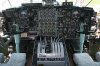
We use it in the legacy C-130, we have no FMS, no real GPS/RNAV solution, half of our planes only have a single INS so it's real good back up over the ocean. We also have no navaid database, so when we are issued direct we have to find the point on a Hi chart , Lo chart, or approach plate and type in the lat long to go direct (and again that's an INS lat/long, not a GPS solution, so if the INS has drifted even your ground based lat/long will be incorrect, so we do back up with TACANs to the max extent possible). At least with foreflight you can quickly find the waypoint name and the lat/long. Our other moving map program is windows 95 based and while it's adaquete for tactical situational awareness ie threats, communication with C2, comm with TACP, location of friendly/enemy forces etc, again it has no database and does not help with navigation. Oh ya and guys pay out of pocket for it.
Reminder in case anyone flying an -88 wants to complain The only people I feel bad for are B-52 guys, but even they have like what 3 navigators?
Yeah, I was talking to some B-2 guys that were telling me about how they use it when they're flying T-38s for currency. Pretty enlightening, really.
Is flying a twin turbojet airliner with round dial instruments by VOR and NDB only really that hard?
NDB? What is this sorcery you speak of?
Sent from my Startac using Tapatalk.
Oh ya and guys pay out of pocket for it.