DIY Logbook advice

zmiller4

Well-Known Member
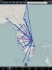
I just finished formatting my Excel logbook I've had since 2001 for potential upcoming interviews, and I'm going to get it printed and bound at a Fedex or something on green card stock paper (like the Jepp professional book) with opaque plastic covers. For the cover, I was thinking about going with a map of North America, either blank or with line segments for the flights I've flown over the past 7 years. What's the collective JC opinion....no map (just name and cert #), blank map, or map with flights?

coverplain-01.jpgcoverlines.jpg

If anyone's interested, the maps were made manually in ArcGIS using airport coordinates, state shapefiles, and the US Geological survey's Hydro 1K digital elevation model.
 
Is this being used for interviewing? If so, I'd say no map on the cover. Otherwise, put the flight segments in.
 
You might want to mention that you have been to Chicago once or twice :D

On a separate note, I actually think that the map is a great idea.
 
On a separate note, I actually think that the map is a great idea.

Thanks! I like the idea of some graphics on the cover, but the segment map is pretty busy and disjointed at the size I'd have to make it for a logbook cover. I'll probably just put name and certificate info. This is what the "real" one I made looks like with color and thickness corresponding to the number of times I flew that segment.

flyingmap_small.jpg
 
What program did you use to generate the segment map?

It's done mostly in ArcGIS, which I have an academic license for...otherwise it costs thousands. I think most logbook programs will do something similar, but I doubt you can get the customization you can get with a good mapping program.
 
What program did you use to generate the segment map?


I used to do something similar in ForeFlight. Just enter your destinations in the flight planning area. Downside - this will take forever for guys with thousands of airports. (Unless you can somehow copy from an excel and paste, I haven't tried that yet). Pick a map layer, then zoom out to the scale you want, take a screen-shot and crop.
 
I think the segment map looks much better than the initial 2 in the first post. Good luck on the interviews
 
I was trying to come up with more graceful arcs like you see on airline route maps and was having a heck of a time making that work in GIS software. I ended up using Google Earth with this as an artistic impression of routes out of the airport I've flown the most.

SFOLMB.jpg
 
I was trying to come up with more graceful arcs like you see on airline route maps and was having a heck of a time making that work in GIS software.

I don't think any professional route maps are made solely using GIS software--segments are drawn along some sort of line (like great circle or rhumb) that has geographic meaning. If you want the huge swooping things they make, there's probably some cheaper editor you could use after bringing the map out. Adobe gives a 30 day Illustrator trial for free and there's simple ways to do it there if you don't mind manually editing line segments.
 
I was just hoping that I could find some GIS plug-in that would allow me to create great circle routes between airport pairs rather than straight lines in the current projection. For most of my mapping I use Illustrator (I really miss FreeHand). Straight GIS still produces uglier maps than it should, IMHO.
 
I was just hoping that I could find some GIS plug-in that would allow me to create great circle routes between airport pairs rather than straight lines in the current projection. For most of my mapping I use Illustrator (I really miss FreeHand).


For ArcGIS? It's available in Arc 10.x under the "XY to line" tool--lets you calculate a number of line types between points. Problem is that great circle lines look straight at the distances most of us fly--I had 1200+ mi legs that looked straight with great circle segments.

Straight GIS still produces uglier maps than it should, IMHO.
No kidding! You can always tell when someone has just used GIS. I usually make the base figures in it and then finish in Illustrator.
 
Back
Top