KJAC ILS 19 Y

MOGuy424

Well-Known Member
Question about this approach, if anyone could help me out is appreciate it.

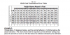
In the profile view there is a note (*) by the 7500 for LOC MDA then on the left it says "S-ILS 19 Fly Visual 187degrees 1.8 NM.

Could someone explain what this is referring to and instructing to do?

Thanks!

h
00504IYL19.PDF
 
It means that from that point you have to be able to see and navigate to the runway visually. The 187 and 1.8nm are the distance and direction from that point for both situational awareness, as well as defining the point. If you reference the minimums, they allow for 2nm visibility...so you should see the runway at 1.8.
 
It means that from that point you have to be able to see and navigate to the runway visually. The 187 and 1.8nm are the distance and direction from that point for both situational awareness, as well as defining the point. If you reference the minimums, they allow for 2nm visibility...so you should see the runway at 1.8.

Okay I see. I guess it didn't make sense bc it is for the ILS. In me experience you either see it at DH or not. But I guess if you happened to see the ALS at DH but not the runway you could theoretically continue down to 100' above TDZE by flying the 187 degrees, but that far out why not just follow the Lovalizer if you're still that far out?
 
It means that from that point you have to be able to see and navigate to the runway visually. The 187 and 1.8nm are the distance and direction from that point for both situational awareness, as well as defining the point. If you reference the minimums, they allow for 2nm visibility...so you should see the runway at 1.8.

Okay here's another. What does the negative snowflake mean in the alternate box? I looked all over the legend but can't find it.
 
Okay here's another. What does the negative snowflake mean in the alternate box? I looked all over the legend but can't find it.

It probably means that there are temperature limits or corrections that need to be applied when you are doing the approach. Since the airport is at altitude there can be a lot of altimeter error if you don't apply a correction for really cold temperatures.

Just a WAG and I'm no expert but it may help you figure out the answer.

The big gotcha that I remember from this airport is that you had to observe single engine climb performance for the missed approach climb. There are two different ILS approaches one has much lower minimums but it also has very tough single engine climb gradients, so many aircraft shouldn't be doing the approach. They don't have the single engine climb performance to make it from the missed approach point to a safe altitude.
 
There's a fairly significant NOTAM about this approach, too, which specifies an increase the in the required climb gradient but I can't find it now.

@BEEF SUPREME is correct about the snowflake - there are altimeter corrections related to these temps, but I can't find the doc at the moment that explains it. I think it's in an AC, but I'm still looking for it. I'll post if I can find it.
 
Its funny, we were trained on the cold temp restricted airports in January. But the snowflake just now showed up on the recent set of NOS charts.
 
This is why GPS altitude should be able to be used, I remember seeing GPS altitudes 1000' lower or more in the winter months when going out to C05 and PAKA across the Chugach.
 

Attachments

  • Screen Shot 2015-07-10 at 1.35.15 PM.png
    Screen Shot 2015-07-10 at 1.35.15 PM.png
    81.1 KB · Views: 141
Back
Top