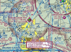
Just curious what your method is for transitioning an area with a parachuting symbol next to the airport. I didn't really see a concrete answer in the AIM so I thought I'd see what your thought process and proximity to the airport would be. I'm mainly focused on the airport attached where it's a fairly tight squeeze between the alert area above and the charlie below.
I would venture to say that staying around I4 would be far enough and then just monitor the frequency and be very alert as to what is going on.
Let me know your thoughts!
KDED is a very busy dropzone. If you listen to the AWOS, it will basically tell you "skydiving operations during the daylight hours. Do not overfly the airport" - there's two places to eat at on the property - so if you decide to do that don't overfly to join a pattern, go around to whichever side you need.
Alert area is just that - busy training area. Freq is 122.85 if nothing's changed. Reporting points are lakes - from north to south - Crescent lake (bigger lake with a hook at the bottom), lake Diston (diamond shaped lake), lake Dias/twin lakes (couple of west-east lakes just west of Lafayette private strip). Listen in on who's where, say where you are (Practice area North, Cherokee 123AB east shore of lake Crescent southbound 5500 feet) and that's about it. Stay couple of miles to the either side of DED.
If going south, cut from DED to I4, watching for DAB airspace bit, and follow the I4. There will be one more jump site further south at Dunn airpark.
Best thing to do is get flight following, they will notify you of the dz activities.
If not, listen in on ctaf - Deland is very good about announcing and/or asking you to drive around.
Lived in Deland for 6+ years, ask if you have any questions about the area