Altimeter settings and temperature

Xcaliber

El Chupacabra
I feel that as a CFII and ATP I really should know how this stuff works by now.

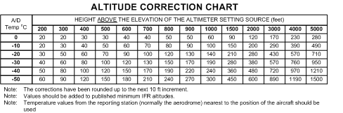
So I was thinking upon altimetery today. We're given an altimeter setting on the ground, which presumably is only corrected for non-standard pressure. We set in that and low and behold, we see the airport elevation, within a margin of error for the system. On my aircraft, that margin is 75' if I'll be flying in RVSM. That's all hunky-dory on a standard day. But we also know that on a non-standard day, especially cold days, we have to watch out for our true altitude being different than indicated. Based on some quick E6-B action, I figure that (depending on airport elevation), any time the temperature is more than about 4 or 5 degrees C from standard, I'd be outside of my aircraft limits. Ie, my indicated altitude would be more than 75' off from field elevation.

Now obviously that doesn't happen. If I set in the given altimeter setting, it's usually well within limits. So that means either one of two things...either temperature doesn't have as big of an effect on true altitude as I thought, or, more likely, I've been taught (and teaching...) wrong all these years and altimeter settings DO in fact take in to account non-standard temperatures. Does anyone have any sources on how altimeter settings are generated? Are there some older systems out there that might not take temperature into account?

On a somewhat related note, do aircraft with Air Data Computers automatically correct for non-standard temperatures? I've never read anything about any systems that do, but you would think that it'd be feasible to do it.
 
The altimeter setting does account for non standard temp "on the ground" ONLY. (Think of a guy on the ground in an airplane (or tower), that sets his altimeter to field elevation, and reads the altimeter setting. This is what is broadcasted!)

However, the further you go up in altitude, the further the error will be when non standard temp. Thats why when you read an altimeter correction chart, it is based on AGL height with 0 AGL feet having 0 error.


.
winter2.gif


Make sense?
 
In cruise, its no factor, When your shooting an approach into Aspen Colorado on a negative 40 degree day, and the minimums are almost 3000 AGL, it does become a factor!

ehhhh, the FMS does it for you.
 
Cold weather altimeter correction is (and always has been) necessary at certain airports. If you are required to correct for cold temperatures on an approach there will be a note on the approach plate.

https://www.aopa.org/news-and-media/all-news/2015/april/pilot/t_mm
What gets me about that, why can't this correction be "baked" into the altimeter setting? My damn jepp books are already busting at the seams, and we keep having to add more paper. (I know, I know..... ipad)
 
What gets me about that, why can't this correction be "baked" into the altimeter setting? My damn jepp books are already busting at the seams, and we keep having to add more paper. (I know, I know..... ipad)

Your altimeter is only capable of taking a barometric pressure (for example, 4,000 feet at ISA would be 25.92") and converting it into an altitude on the dial, which is adjusted by the Kollsman window.

If it's a really cold day, the vertical distance between 25.92" (what the altimeter "thinks" is 4,000 feet) and 24.92" (what the altimeter "thinks" is 5,000 feet) is compressed, due to higher air density.

It would be impossible to build this correction into a mechanical altimeter. I'm not sure if it would be possible to apply an automatic correction to an EFIS altimeter, since cold weather correction charts rely on surface temperature and not air temperature at altitude.
No, I get that. But couldn't the ASOS/AWOS whatever read the temp, add in an algorithm for the correction?
 
No, I get that. But couldn't the ASOS/AWOS whatever read the temp, add in an algorithm for the correction?

Isn't the AWOS altimeter setting already adjusted for temperature in order to read correct field elevation? If there was no correction applied to the AWOS altimeter setting on a cold day in Aspen, wouldn't my altimeter read well below field elevation?

Not sure what you mean by an algorithm. Cold weather altimeter correction varies by height above airport, not sea level, which again leads me to believe that the altimeter setting on the AWOS is adjusted to correct for temperature at field elevation.

Altitude%20correction%20chart.gif
 
No, I get that. But couldn't the ASOS/AWOS whatever read the temp, add in an algorithm for the correction?

This...
Isn't the AWOS altimeter setting already adjusted for temperature in order to read correct field elevation? If there was no correction applied to the AWOS altimeter setting on a cold day in Aspen, wouldn't my altimeter read well below field elevation?
...and this, is exactly what I was asking.

Cold weather altimeter correction varies by height above airport, not sea level, which again leads me to believe that the altimeter setting on the AWOS is adjusted to correct for temperature at field elevation.
The altimeter setting does account for non standard temp "on the ground" ONLY. (Think of a guy on the ground in an airplane (or tower), that sets his altimeter to field elevation, and reads the altimeter setting. This is what is broadcasted!)

However, the further you go up in altitude, the further the error will be when non standard temp. Thats why when you read an altimeter correction chart, it is based on AGL height with 0 AGL feet having 0 error.

.
winter2.gif


Make sense?

...and this was the conclusion I had come to after thinking about it for a bit.

It's just that I wasn't taught that, nor has anything I've read explained that. It makes sense, but it caused enough confusion in my head to ask you wonderful people. Though my last question still stands, are there any old (or cheap) systems out there that don't take temperature into account, or have they been designed from day 1 with that in mind?
 
Who cares? Everyone is using the same altimeter setting so everyone is wrong by the same amount.

There are some pretty decent altitude errors at relatively low altitudes with moderately cold temps.

I remember flying to Chenega Bay on a cold day and noticing that the mountain seemed to be 1000' higher...

"High to low and Hot to Cold look out below."
 
Though my last question still stands, are there any old (or cheap) systems out there that don't take temperature into account, or have they been designed from day 1 with that in mind?

I think even the old (cheap) systems still account for temp even though it was not intended to when built, and have not changed since. Back they first started using them, they just used an airplane altimeter, and set it it field elevation, and then broadcasted the baro setting (without realizing it was automatically accounting for temp at the same time).
 
For those with the who cares attitude, have you ever thought about your real altitude at low temp in relation to MSA? Good luck with that mountain or obstacle. They definitely do not care about temp either. Btw not all FMSs have a temp correction.
 
Your altimeter is only capable of taking a barometric pressure (for example, 4,000 feet at ISA would be 25.92") and converting it into an altitude on the dial, which is adjusted by the Kollsman window.

If it's a really cold day, the vertical distance between 25.92" (what the altimeter "thinks" is 4,000 feet) and 24.92" (what the altimeter "thinks" is 5,000 feet) is compressed, due to higher air density.

It would be impossible to build this correction into a mechanical altimeter. I'm not sure if it would be possible to apply an automatic correction to an EFIS altimeter, since cold weather correction charts rely on surface temperature and not air temperature at altitude.
The 175 had a magic "TEMP COMP>" button.
 
Back
Top